|
|
|
|
|
|
|
|
Research |
Research Summary:My research in fluvial geomorphology and hydrology unites modeling and field studies in the larger
attempt to understand the evolution of landscapes and their rivers and streams on both human and geologic
time scales. I am especially interested in the interactions between surface processes and plants, especially trees.
|
|
Debris Flows and Landscape Interactions:Simulations with a landscape model incorporating forest-geomorphic interactions in the Oregon Coast Range indicate that the removal of wood from mountain watersheds would likely result in at least doubling the average runout length of debris flows and increasing the maximum runout length by 400%. These results, part of the Coastal Landscape Analysis and Modeling Study (CLAMS), a collaboration including researchers from OSU's College of Forestry and the USDA Forest Service Pacific Northwest Research Station, suggest that timber harvest could have large consequences for both hazards and aquatic habitat by promoting extension of debris flow impacts into valleys and streams previously unaffected by such catastrophic processes.
Current Projects:Application of the CHILD model to determine the probability of wood and sediment delivery to a critical
reach: This study, funded by the National Council for Air and Stream Improvement (NCASI), will follow up on the above modeling study and examine the effects of forest practices on debris flows and sediment transport, particularly in fish-bearing streams.
|
|
|
Recently, detailed study of sediment deposits at the mouths of two different tributaries with similar-sized mainstem streams in the Oregon Coast Range revealed different dynamics of sediment delivery and storage, as well as different effects on sediment routing through the adjacent mainstems. The smaller (0.14 km2), steeper (10%) tributary has a much larger deposit, a fan composed predominantly of bouldery debris flow deposits, whereas a tributary that is 10X larger (1.5 km2) and half as steep (5%) has a deposit only one-tenth the size and composed predominantly of fluvial silt, sand, and gravel. The sediment residence times, calculated from extensive radiocarbon dating, in the two tributary deposits are actually similar, at 1400 and 1700 years, respectively, and in both cases a significant amount of sediment remains for several millennia before being evacuated. The key difference between the tributaries is that sediment delivery from the smaller one is dominated by debris flows with a recurrence interval of about 100 years, whereas debris flows usually stop upstream of the mouth of the larger. The smaller tributary's fan-shaped, bouldery deposit traps 60% or more of the sediment eroded from the contributing watershed, but less than 1% of the larger tributary's deposits are trapped at its mouth. The delivery, or not, of debris flows to the mainstems has a substantial, and somewhat counter-intuitive, effect on sediment storage in the adjacent mainstem valleys. Bouldery deposits delivered by the smaller tributary help the adjacent mainstem valley store about 7X the amount of sediment stored in the mainstem adjacent to the larger tributary, but the residence time of sediment in the latter valley reach is almost 10X greater (4000 years vs. 400 years): debris flows entering the former stream force its channel to move and therefore erode deposits more frequently than in the latter, where boulders from infrequent debris flows trap some sediments for much longer times, some exceeding 10,000 years. This study implies that small, steep, debris flow-delivering tributaries have disproportionately large effects on the delivery, storage, and transport of gravels crucial for the spawning of threatened and endangered salmonids. |
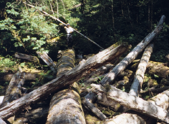
A debris flow deposit with boulders exceeding 2 m diameter (30 m tape measure for scale) overlies strata of matrix-supported gravels, clast-supported fluvial gravels, and smaller boulders in the left bank of Golden Ridge Creek on the Tyee Formation (Eocene interbedded sandstone and mudstone) of the Oregon Coast Range. Large charcoal fragments are visible embedded in the matrix between the two largest boulders, and the abundance of charcoal in these and similar deposits enables estimation of their ages by radiocarbon dating. Photo by Stephen Lancaster, 2006. |
|
Evolution of Landscapes Dominated by Debris Flows: This study, funded by the National Science Foundation (Geomorphology and Land-use Dynamics, EAR-0643353), will use landscape evolution modeling, LiDAR, and field instrumentation and measurement to examine the processes responsible for steepland valley and longitudinal channel profile evolution in the Oregon Coast Range and the Italian Apennines. |
|
|
|
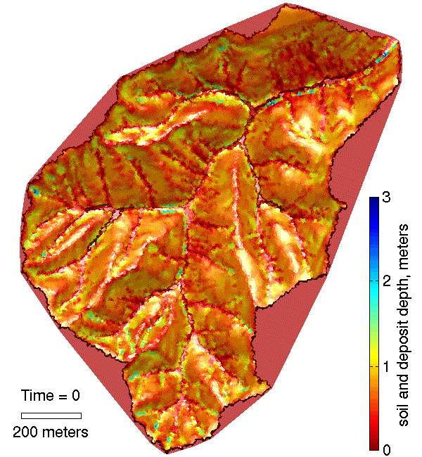
Animation of 3000-year simulation of forest growth, death by fire, storms, soil production and diffusion, landslides, debris flows, and fluvial sediment transport. In the animation and the image (left), the shaded relief map is colored according to soil and sediment thickness. Following debris flow events, thick deposits appear throughout the network. They seem to melt away as the wood constituent decays. Fluvial transport reworks the sediment. The results of this simulation were published in Lancaster et al. (2001).(Download zip-file of animation: zip-file) |
River Meandering and Landscape Interactions:An analysis of historical bank erosion rates of the Willamette River, Oregon, with a model of river meandering recently provided the first quantitative measurement of the erodibilities of different geologic units forming the river's banks. Specifically, we found that modern floodplain deposits are only 2-4 times more erodible than partially cemented sediments likely deposited during the last ice age. While artificial revetments were found to be ten times more resistant than the banks formed of ancient deposits, the lack of revetments on these naturally resistant banks suggests that landowners are actually comfortable with moderate rates of bank erosion such as might be accomplished by replacing revetments with natural vegetation. This research was conducted in collaboration with a project funded by the National Science Foundation's Biocomplexity Intitiative and including researchers in OSU's Departments of Bioengineering and Fisheries and Wildlife and UO's Department of Landscape Architecture.
Current Projects:Heat Budget in the Hyporheic Zone of a Large, Gravel-Bed River: This pilot study, funded by the National Science Foundation (Hydrological Sciences, EAR-0538075) will use hydrologic and geophysical field techniques and hydrologic modeling to quantify the heat budget of a single gravel bar on the Willamette River, Oregon.
|
|
During my thesis work, I developed a new, simple, nonlinear model of river meandering; new analytical tools for identifying inherent length-scales of meandering on channel planforms and the average sinuosity at those length-scales; and used those new analytical tools to compare real meandering streams to those produced by my new model and the more physically-based model of Johannesson and Parker (1989) (Lancaster and Bras, 2002). |
|
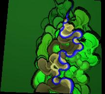
In the animation, the model stream flows from top to bottom. Stream coordinates are translated onto a grid. When the channel reaches a pixel, its elevation is set to that of the channel bed. Once the channel vacates a pixel, its elevation is left at the elevation of the channel bed at the bank. The rest of the "landscape" is uplifted at a uniform rate, so pixel elevation is proportional to time since channel occupation. Pixels are colored by elevation: blue, tan, brown, light green, dark green from lowest to highest. |
|
In the course of the meandering study, I looked at migration of the Ellis River, Maine, with aerial photos. |
|
© Stephen Lancaster stephen lancaster Last modified: Mon Mar 29 2010 |